Tremendously Terrific Tips and Tricks Part 2: Google Maps!
YOU ARE NOT EVEN READY….What I am about to share is GOLD… Teaching GOLD!
Those of you who observed me at iFLT  in Denver  or at Express Fluency in Vermont this year may have seen me do this with my kids. I used this MIND blowing trick in my learning labs, where I have one rule for my adult “teacher observers”.
- Be paint on the wall! (do not be a distraction to the students in the class!)
The first time I used this at both conferences, many, (not one or two, not several, but MANY) of the teachers in the room broke this one rule. They gasped and frantically started writing in their observation notes.
With Google Maps, in just a few clicks, I can take my children on a field trip to ANYWHERE in the world, without even stepping out of my classroom. It is truly magical. Watch this little demo, the first is fast and then I will explain slowly and in detail each step and how I use it!
DID YOU FAINT?!?!!?! I mean…. Honestly, I wanted to faint the first time I used it in class. The kid’s faces, I will NEVER ever EVER forget their faces the first time. I had used it with my Uncle Jim before to zoom in and show him where I used to live in China. One day my kids picked a location for a character to live in Jerusalem. Then they were arguing over what type of house this character would live in… (which we all know I hate and that is why I use white lies and story cubes to avoid it) That day however, I decided to open up Google Maps, and I went to the Satellite view, and then typed in “Jerusalem”. Within 10 seconds the map went from our tiny school in New Orleans, Louisiana to an overview of Jerusalem! Their mouths were wide open…. I had goosebumps. Then I grabbed the little man in the bottom right hand corner and swung him over the city, and dropped him. 5 seconds later we found ourselves in the streets of Jerusalem. It is making me emotional to even remember their little faces staring in amazement. 7th graders…. absolutely bowled over by the magic I had just performed. It gets BETTER! We had been “dropped” in a busy street with kids playing with a ball and what appeared to be apartments all around them. THAT is where are character lived. Honestly though, we ditched the story and just talked about what we saw (yes, in the TL). We drew important comparisons between the houses and cars we were seeing and the cars and homes that my kids live in. We noticed what the children were wearing and compared it to their clothes. We wondered whether they were playing soccer like the boys do at recess here! We panned around and saw a market and talked about the difference between shopping in a street market and shopping at the local Winn Dixie (King Soopers in the North!) It was truly magical. The kids (AND I )Â NEVER wanted that class to end.
If you already know how to use Google Maps, the rest of this blog is probably irrelevant… however, it may be highly entertaining as I try to write and demonstrate HOW to use it in basic terms…
- First, go to maps.google.com it should bring you to a “street view” of wherever you are. (You are the blue dot)
- Next, click in the bottom left hand corner to go to “satellite view” at which point you should see what your area looks like from outerspace! COOL, HUH!?!?
- After that, you can use the + and – buttons on the bottom RIGHT hand corner to control zooming in and out of the area. At this point you can zoom ALL the way out and see the WHOLE world on your screen…. I KNOW!!! STOP! It is SO good! SOOOO GOOD!
- Here is my example of those steps below:
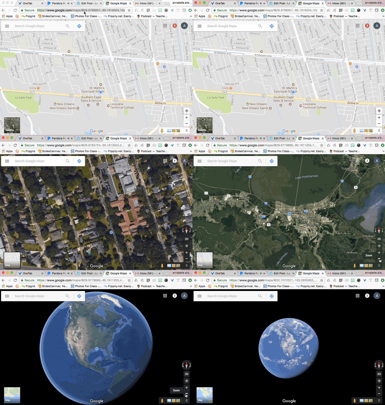
NOW, you have a couple of different options.
- You can move the world around and zoom in to the country you want to see (using the + button on the bottom right hand side of the screen) OR
- On the TOP LEFT you will see a search bar that says  “Search Google Maps”
- There you can type in a city, town, or country that you want to “virtually visit” with your class
- Personally, I like to type in a country, because it will ZOOM all the way in to whatever you type there, so if I type in the country first, I can then zoom in manually myself to a specific city.
- I also like this because I can zoom OUT when it brings us TO the country and I can compare where IT is to OUR location in class
- Personally, I like to type in a country, because it will ZOOM all the way in to whatever you type there, so if I type in the country first, I can then zoom in manually myself to a specific city.
- There you can type in a city, town, or country that you want to “virtually visit” with your class
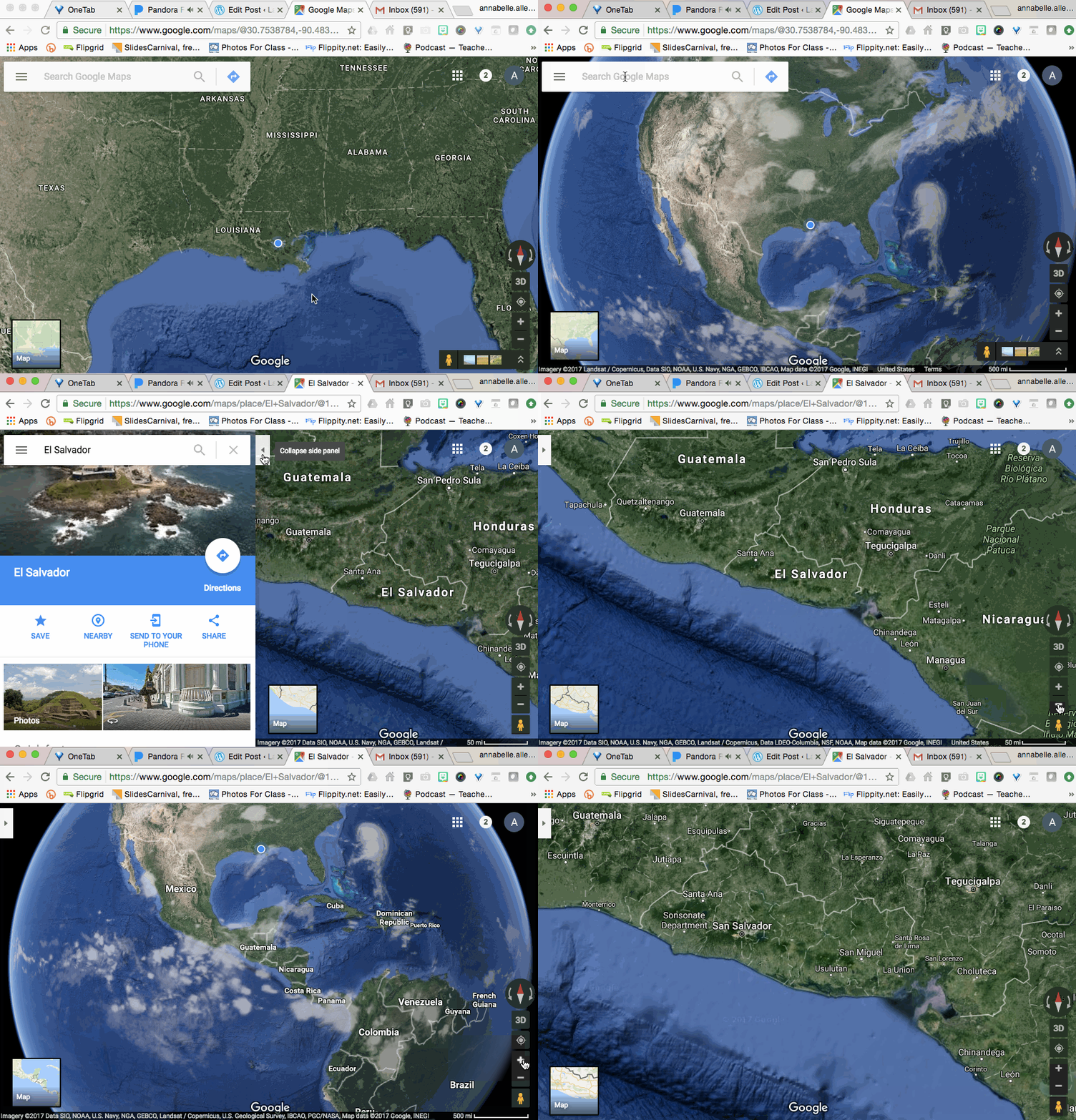
Next, you want to blow their minds more and go to street view!
- First you have to zoom in CLOSE enough to see whether or not Street View exists in that area.
- The best way to tell is to pick up the little yellow stick figure in the bottom right hand corner (below the + and – sign) and swing him over the map. If street view exists, BLUE will light up on the map….
- In this video you can see that I saw blue but I wanted to be even closer so I put the man back in the corner and zoomed in more before grabbing him and dropping him over the map. (THIS POOR LITTLE DUDE!)
- FOR ADDED EFFECT, scream and holler as you swing the little dude around over the map. Elementary kids particularly LOVE this….
- I was dropped into some sort of park in San Salvador, El Salvador. SO cool.
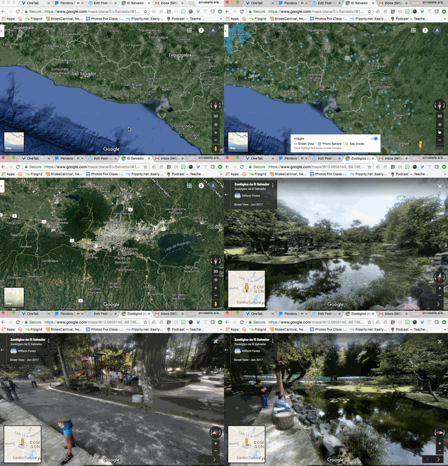
You may have noticed, I was rotating around looking at the park and the people in it. Did you notice the girl with ONLY legs?! haha! That happens sometimes and it is SO fun when it does! Talk about it! Use it! YES! In the TL! ALWAYS in the TL! All it means is that when the cameras photographing for the street view, the girl moved so it only caught SOME of her. (In Vermont there was a FLOATING HEAD in the streets of Rome next to the Colosseum! haha! It resembled one of the little girls in my class which was HYSTERICAL!)
Next I want to show you how you can MOVE around!
- Sometimes when you get “dropped” into street view, especially in cities, you will see little arrows on the ground. If you click on those, you can move up and down the streets without “exiting” to satellite view again.
- Don’t forget to look around each time you move! You never know when you might see a cool animal in the street or maybe a person transporting TONS of fruit, 2 pigs, 4 family members, and three backpacks on a tiny little scooter!!!
- You can see in this example, the FIRST time I was “dropped” I didn’t see the arrows on the ground that I was looking for, so I exited street view and went back to satellite view again so I could find a different spot!
- All I did was click the little X in the top right hand corner.
- OR you could exit by clicking on the big square in the bottom left hand corner of the screen.
- All I did was click the little X in the top right hand corner.
To make this even more special, in Elementary school, have kids YELL “HOLA” or “BONJOUR” to the people they see in the street. (I tell them they can actually hear them! (PRECIOUS!)
USE THIS FEATURE! Any time my kids mention another “place” I take it as an opportunity to explore the world with them! How FUN!
I can’t say enough about this “trick”. As foreign language teachers we have a responsibility to the children in our classroom to teach them about cultures and peoples different from their own. For many children, this may be the one opportunity they really have to “see” the world outside of their city. For others, you may inspire them to travel and see the world. Teaching our students to be a global citizens who can truly appreciate cultures and customs different from their own, is one of the most important and SPECIAL parts of our jobs! How lucky we are!
YAY!
WHEW! Tough to top this one! but DO NOT WORRY! I have something AWESOME planned for tomorrow too!
YAY!
Until then,
HAPPY TEACHING!
Love,
La Maestra Loca
P.S. (Aren’t my little demo videos from yesterday’s blog and today’s SO cool!?!?! My amazing tech guys taught me about this! James and Gary! They pretty much save my butt every day! LOVE THEM!)

Hello Annabelle,
I have found Google Maps a terrific tool for teachers and students. Not only is interactive but, like you said, you can take your students anywhere.
I used Google Maps in one of my assessments for one of my units. I will implement it again this year but I have to ask you for advice. Last year I had students to give me directions in Spanish from point A to point B. They had four different options ( important monuments from Spanish speaking countries). For example, they had to do research on “La Sagrada Familia”, explain it to me in the TL, then give me directions from, let’s say, Starbucks to La Sagrada Familia Church. It was very fascinating for them to check out the street view and being able to navigate through out streets. However, it did not turned out like I wanted.
I think this year I would want them to find a place but I will give them the directions.
Let me know your thoughts.
Best,
Vanesa Gray
I love your new idea. I think it is important to consider first WHAT you are assessing. For me, I would rather assess their ability to interpret language so READ or LISTEN to my directions or instructions and get somewhere. I find that students are much more successful in “speaking assessments” when they aren’t aware it is an assessment at all. The pressures of presentational speaking can have a serious effect on the affective filter. I am glad you enjoy google maps as much as me! So fun! Enjoy your year Vanesa!!!
I don’t know how many hours you have in your day!? Thanks so much for taking the time to share your creative ideas every day when you’re beginning your school year and have a montón de cosas que hacer.
DE NADA! Thank you for notes like these! When I know what I am writing is helping teachers out, it inspires me to write more! 🙂 Love, Annabelle
Simply brilliant! You are so fun! Can’t wait to squeal as I fly and swing the little dude around! HS Freshmen will learn how crazy I can be!
They will LOVE it! haha!
Thanks for sharing! Keep your great tips coming. What a great way to incorporate cultural information!
<3 So fun!